|
 The HYCOM consortium is a multi-institutional effort sponsored by the National Ocean Partnership Program (NOPP), as part of the U. S. Global Ocean Data Assimilation Experiment (GODAE), to develop and evaluate a data-assimilative hybrid isopycnal-sigma-pressure (generalized) coordinate ocean model (called HYbrid Coordinate Ocean Model or HYCOM). The GODAE objectives of three-dimensional depiction of the ocean state at fine resolution in real time, provision of boundary conditions for coastal and regional models, and provision of oceanic boundary conditions for a global coupled ocean-atmosphere prediction model, are being addressed by a partnership of institutions that represent a broad spectrum of the oceanographic community. The HYCOM consortium is a multi-institutional effort sponsored by the National Ocean Partnership Program (NOPP), as part of the U. S. Global Ocean Data Assimilation Experiment (GODAE), to develop and evaluate a data-assimilative hybrid isopycnal-sigma-pressure (generalized) coordinate ocean model (called HYbrid Coordinate Ocean Model or HYCOM). The GODAE objectives of three-dimensional depiction of the ocean state at fine resolution in real time, provision of boundary conditions for coastal and regional models, and provision of oceanic boundary conditions for a global coupled ocean-atmosphere prediction model, are being addressed by a partnership of institutions that represent a broad spectrum of the oceanographic community.
The partnership members are the Florida State University Center for Ocean-Atmospheric Prediction Studies (FSU/COAPS), the University of Miami Rosenstiel School of Marine and Atmospheric Science (UM/RSMAS), the Naval Research Laboratory/Stennis Space Center (NRL/STENNIS), the Naval Oceanographic Office (NAVOCEANO), the Fleet Numerical Meteorology and Oceanography Center (FNMOC), the Naval Research Laboratory/Monterey (NRL/MONTEREY), the National Oceanographic and Atmospheric Administration/National Centers for Atmospheric Prediction/Marine Modeling and Analysis Branch (NOAA/NCEP/MMAB), the NOAA National Ocean Service (NOAA/NOS), the NOAA Atlantic Oceanographic and Meteorological Laboratory (NOAA/AOML), the NOAA Pacific Marine Environmental Laboratory (NOAA/PMEL), Planning Systems Inc., Los Alamos National Laboratory (LANL), Service Hydrographique et Océanographique de la Marine (SHOM), Laboratoire des Ecoulements Géophysiques et Industriels (LEGI), The Open Source Project for a Network Data Access Protocol (OPeNDAP), the University of North Carolina (UNC), Rutgers University, the University of South Florida (USF), Fugro-GEOS/Ocean Numerics, Horizon Marine Inc., Roffer's Ocean Fishing Forecasting Service Inc. (ROFFS), Orbimage, Shell Oil Company, ExxonMobil Corp., the NOAA/National Weather Service/Tropical Prediction Center (NOAA/NWS/TPC), the NOAA/National Weather Service/Ocean Prediction Center (NOAA/NWS/OPC), the University of Michigan, and the University of the Virgin Islands (UVI).
The academic, governmental, and commercial entities involved in the partnership have long histories of supporting and carrying out a wide range of oceanographic and ocean prediction-related research. All institutions are committed to developing and demonstrating the performance and application of eddy-resolving, real-time global, Atlantic, and Pacific ocean prediction systems using the HYbrid Coordinate Ocean Model (HYCOM), a data-assimilative hybrid isopycnal-sigma-pressure (generalized) coordinate ocean model.
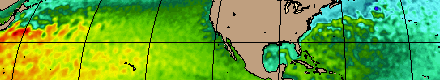
 The prediction systems will be transitioned for operational use by the U.S. Navy at the Naval Oceanographic Office (NAVOCEANO), Stennis Space Center, MS, and at the Fleet Numerical Meteorology and Oceanography Centre (FNMOC), Monterey, CA, and by NOAA at the National Centers for Environmental Prediction (NCEP), Washington, D.C. The systems will run efficiently on a variety of massively parallel computers and will include sophisticated data assimilation techniques for assimilation of satellite altimeter sea surface height and sea surface temperature as well as in situ temperature, salinity, and float displacement. The partners intend to make results available to the GODAE modeling community and to general users on a 24/7 basis via a comprehensive data management strategy. The prediction systems will be transitioned for operational use by the U.S. Navy at the Naval Oceanographic Office (NAVOCEANO), Stennis Space Center, MS, and at the Fleet Numerical Meteorology and Oceanography Centre (FNMOC), Monterey, CA, and by NOAA at the National Centers for Environmental Prediction (NCEP), Washington, D.C. The systems will run efficiently on a variety of massively parallel computers and will include sophisticated data assimilation techniques for assimilation of satellite altimeter sea surface height and sea surface temperature as well as in situ temperature, salinity, and float displacement. The partners intend to make results available to the GODAE modeling community and to general users on a 24/7 basis via a comprehensive data management strategy.
This collaborative partnership provides the means to leverage and accelerate the efforts of existing and planned projects, as well as new opportunities for collaboration and cooperation among the partners ranging from research to the operational level. The anticipated results of this effort include integrated analyses/reanalyses for research programs, a foundation for model enhancement based on testing of hypotheses, synthesis of remotely sensed and in situ data, and inputs to coastal, regional, atmospheric, and ice prediction systems. Improved open-ocean nowcasts and forecasts will be applied to search and rescue operations, shipping routes, tracking of icebergs and major pollutants, commercial fisheries, etc. |